A Study of Land Function Conversion and Urban sprawl Patterns in Sokaraja Banyumas Regency
DOI:
https://doi.org/10.53017/uje.103Keywords:
Building Area, Agricultural Land, Land Function Conversion, Urban sprawl PatternAbstract
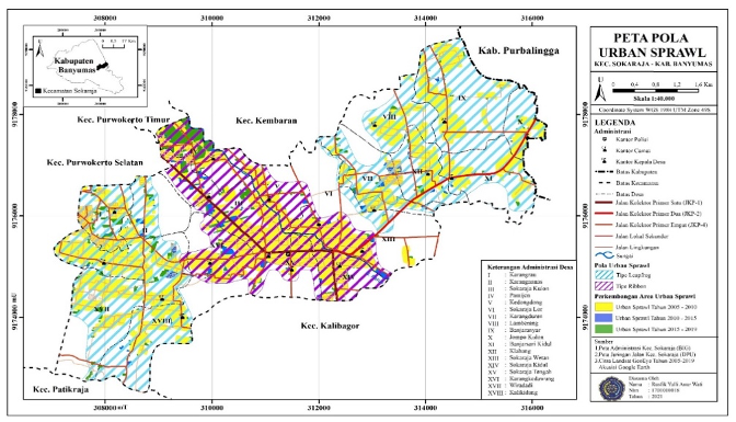
Urban sprawl is a phenomenon of the unplanned physical appearance spread in the city due to the rapid development of the city. The limited availability of land triggers its development to extend to the suburbs which causes land conversion. This phenomenon occurs due to the development of the city which continues to grow but has limited space. This study aimed to spatially examine land-use conversion and urban sprawl patterns in Sokaraja as a WPU (peri-urban area) from Purwokerto and its close distance to Purbalingga City. This study used a qualitative descriptive method to analyze land-use conversion and urban sprawl patterns using built-up area indicators including settlements and places of activity, agricultural land, and road network. The study was conducted on land use spread over 18 urban villages. Remote sensing analysis with image interpretation of the ArcGIS 10.6 software application was used to review four-time series, namely 2005, 2010, 2015, and 2019. The results of the study found that in a span of 14 years there had been a land conversion in Sokaraja subdistrict. This is evidenced by the increase of the building area which includes settlements and places of activity by 261,991 Ha (8,901%) and followed by a decrease in the area of agricultural land by 261,991 Ha (8,901%). The urban sprawl pattern found is a combination of leapfrog development and ribbon development.
Downloads
References
H. S. Yunus, Struktur Tata Ruang Kota. Yogyakarta, Yogyakarta: Pustaka Pelajar, 1999.
BPS Sokaraja, Kecamatan Sokaraja Dalam Angka Tahun 2005, Kecamatan Sokaraja: Badan Pusat Statistik, 2005.
BPS Kabupaten Banyumas, “Kabupaten Banyumas Dalam Angka Tahun 2020,” Badan Pusat Statistik, Kabupaten Banyumas, 2020.
RTRW Kabupaten Banyumas, “Peraturan Daerah Kabupaten Banyumas Nomer 10 Tahun 2011 tentang Rencana Tata Ruang Wilayah Kabupaten banyumas Tahun 2011-2031,” Kabupaten Banyumas, 2011.
H. S. Yunus, Dinamika Wilayah Peri-Urban Determinan Masa Depan Kota, Yogyakarta: Pustaka Pelajar, 2008.
P. I. Christiawan, “Tipe Urban sprawl dan Eksistensi Pertanian di Wilayah Pinggiran Kota Denpasar,” 2019.
A. Daneshopur dan A. Shakibamanesh, “Compact city?; dose it create an obligatory context for urban sustainability?? International Journal of Architectural Engineering & Urban Planning.,” 2011.
T. Verbeek, K. Boussauw dan A. Pisman, “Presence and trends of linear sprawl: Explaining ribbon development in the north of Belgium. Landscape and Urban Planning,” 2014.
Rabu Agustus 2018. [Online]. Available: https://www.solopos.com/mulai-beroperasi-ini-rute-brt-trans-jateng-purwokerto-purbalingga-933972.
Downloads
Published
How to Cite
Issue
Section
License
Copyright (c) 2021 Rusfik Yulli Anur Wati, Sutomo Sutomo, Sakinah F. Shalihati

This work is licensed under a Creative Commons Attribution-NonCommercial 4.0 International License.